How Much Does Satellite Imagery Cost? Prices per km² Explained
Published satellite imagery prices per km² for 30 cm to 2 m sensors, checked on 22 October 2026, plus the minimum orders, new-capture premiums and license terms that decide what a small project really pays.
 View full-size image ↗
Published list prices for very high-resolution satellite imagery (30 to 50 cm) mostly run from about $8 to $26 per square kilometer for an archive image and about $12 to $33 per km² for a new capture. Imagery at 1.5 to 2 m costs a few dollars per km². Those rates are only half the answer. Minimum order areas, often 25 km² for archive images and 25 to 100 km² for new captures, usually decide what a small project actually pays.
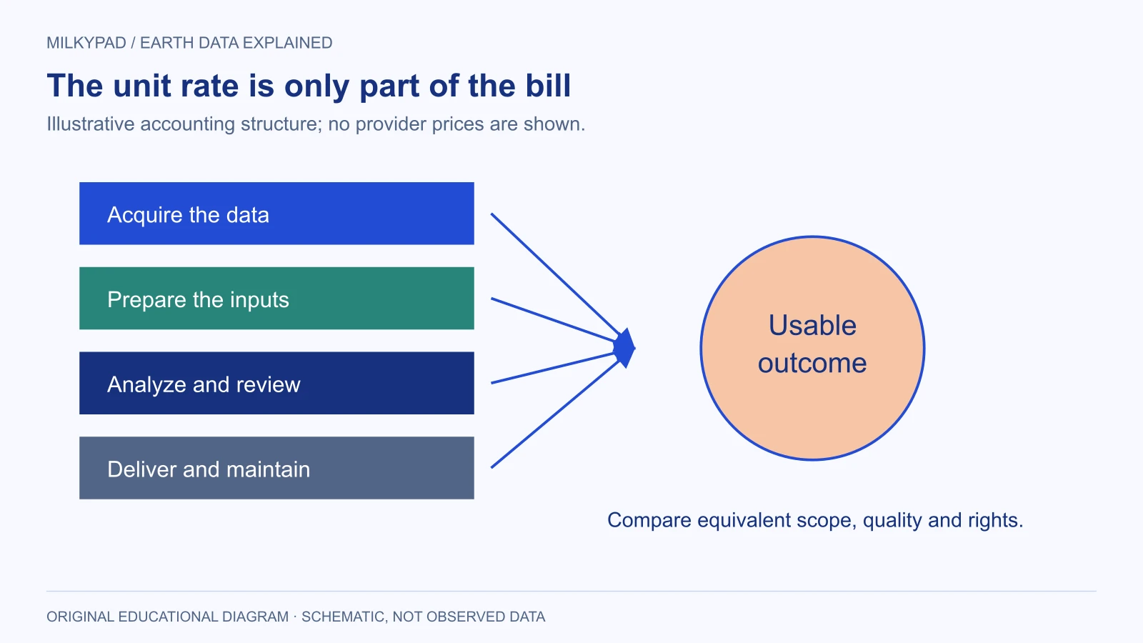
This guide collects list prices that imagery sellers publish, then explains the rules that turn a rate into a bill: minimums, new-capture premiums, licensing and the work after delivery. Every figure below is a third-party list price as published on 22 October 2026. Prices change, and none of them is a Milkypad price or quote.
Satellite imagery price list: published prices per km²
"Archive" means an image already in a provider's catalog. "New capture" means tasking a satellite to collect your area in a future window. Prices are per km² in US dollars unless shown in euros, and minimums apply per contiguous area unless the seller says otherwise.
| Sensor and resolution | Archive per km² | New capture per km² | Minimum order (archive / new) | Published by | Checked |
|---|---|---|---|---|---|
| Vantor WorldView-3 or Legion, 30 cm color | $25.50 | $32.50 | 25 km² / 25 km² | Land Info | 22 Oct 2026 |
| Vantor WorldView Legion or WorldView-3, 30 cm | €22 | from €30 | 1 km² / 25 km² | UP42 | 22 Oct 2026 |
| Vantor GeoEye-1 or WorldView-2, 50 cm color | $15.00 | $25.00 | 25 km² / 25 km² | Land Info | 22 Oct 2026 |
| Vantor GeoEye-1 or WorldView-2, 50 cm class | €13.50 | from €22.50 | 1 km² / 25 km² | UP42 | 22 Oct 2026 |
| Airbus Pléiades Neo, 30 cm | $22.50 | $32.50 | 25 km² / 100 km² | Land Info | 22 Oct 2026 |
| Airbus Pléiades 1A/1B, 50 cm | $12.50 | $21.25 | 25 km² / 100 km² | Land Info | 22 Oct 2026 |
| Airbus SPOT 6/7, 1.5 m | $2.50 | $3.50 | 25 km² / 100 km² | Land Info | 22 Oct 2026 |
| SuperView NEO-1, 30 cm | $20 | $25 standard, $50 priority | 25 km² / 100 km² | EOSDA | 22 Oct 2026 |
| KOMPSAT-3A, 40 cm | $8 (Land Info), $16 (EOSDA) | $18 (Land Info), $24 (EOSDA) | 25 km² / 100 km² | Land Info; EOSDA | 22 Oct 2026 |
| Satellogic ÑuSat, 0.7–0.8 m | $4.50 | from $12 | 16 km² / 10 km² | EOSDA | 22 Oct 2026 |
| Gaofen-1, 2 m | $1.70 | not listed | 500 km² / not listed | EOSDA | 22 Oct 2026 |
| BlackSky Gen-3, 35 cm | $550 per scene | $1,100–1,800 per scene | one scene, about 18–25 km² | EOSDA | 22 Oct 2026 |
| Any 30–49 cm sensor (starting price) | from $19 | from $29 | 1 km² / 1 km² | SkyWatch | 22 Oct 2026 |
| Any 50–99 cm sensor (starting price) | from $10 | from $12 | 1 km² / 25 km² | SkyWatch | 22 Oct 2026 |
| Any 1–8 m sensor (starting price) | from $2.50 | from $3.50 | 1 km² / 25 km² | SkyWatch | 22 Oct 2026 |
Sources: the price lists published by Land Info, EOS Data Analytics (EOSDA), UP42 and SkyWatch, as checked on 22 October 2026. For a price on your own area, request a quote.
Read the table with four cautions. First, Land Info labels its list May 2024, says prices can change without notice and limits it to North American end users; the EOSDA PDF carries no date. Second, "from" prices are floors. SkyWatch says the final price depends on resolution, provider and area, and UP42 shows the lowest-priced product in a collection. Third, UP42 sells in credits, and its published pricing sets 100 credits at €1, which is how the euro figures above were converted. Fourth, the same sensor can carry different list prices at different sellers: KOMPSAT-3A archive is $8 at one and $16 at another.
What the ranges mean for a buyer
At 30 cm, the finest native detail widely sold, archive imagery lists at roughly $19 to $26 per km² and new captures at roughly $25 to $33. At 40 to 50 cm, archive drops to about $8 to $16 and new captures to about $12 to $25. Between 0.7 and 2 m, archive prices fall to a few dollars per km², but minimums can grow: the Gaofen-1 archive row requires 500 km².
Some imagery is not sold by area at all. BlackSky images in the EOSDA list are priced per scene, so a small site and a full scene cost the same. Free public missions also exist and can be the right first look, though their detail is far coarser than anything in the table.
Why the rate is not the bill: minimum order areas
Most sellers charge for the larger of your requested area and their minimum. If your site is 8 km² and the minimum is 25 km², you pay for 25. Ask every seller for both numbers in writing: the area you requested and the area they will bill.
A minimum charge is also different from a technical limit. UP42's Vantor page, for example, lists separate input limits (a tasking area of at least 25 km² and at least 2 km wide) and a separate minimum charge. Paying more does not make an unsupported shape or collection feasible, and a long, thin corridor can fail a width rule even when its area is large.
Normalize offers before comparing them. If one quote covers the whole area of interest and another leaves gaps, comparing totals is misleading. A 4-band multispectral bundle and a 3-band color image are not equivalent just because their pixel sizes match.
Hypothetical example: pricing an 8 km² site
Imagine a fictional landowner who needs a 30 cm image of an 8 km² estate. The site is invented; the rates are list prices from the table above, used only to show the arithmetic. None is a quote.
| Option | Rate | Minimum | Billed area | Imagery subtotal |
|---|---|---|---|---|
| Archive, Land Info list (Vantor 30 cm) | $25.50/km² | 25 km² | 25 km² | $637.50 |
| Archive, SkyWatch starting price (30–49 cm) | from $19/km² | 1 km² | 8 km² | from $152 |
| Archive, UP42 (WorldView Legion, 30 cm) | €22/km² | 1 km² | 8 km² | €176 |
| New capture, Land Info list (Vantor 30 cm) | $32.50/km² | 25 km² | 25 km² | $812.50 |
| New capture, Land Info list (Pléiades Neo) | $32.50/km² | 100 km² | 100 km² | $3,250 |
The same resolution class produces bills from about $150 to $3,250. Most of that spread comes from minimums and the choice between archive and new capture, not from the per-km² rate. For a small site, a seller with a low minimum often beats a lower rate with a high one.
The extras matter too. Land Info's notes list a $10 uplift on new Vantor captures for 10% cloud cover or less (against a 15% default), an 80% high-demand uplift for fresh 30 cm imagery in select regions, and higher prices when more users need access. EOSDA's SuperView NEO-1 row doubles from $25 to $50 when you move from standard to priority tasking.
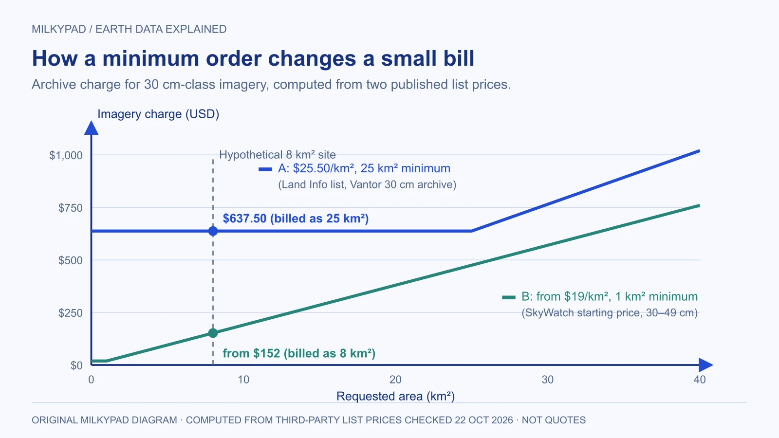
The chart applies two published list prices to every area from 0 to 40 km². Below 25 km², the higher minimum fixes the bill at $637.50; line B uses a starting price, so the real product could cost more.
The choices that move a quote
Resolution. Ask what level of detail the task needs and test it on a sample. Moving from 30 cm to 50 cm cuts the archive list rate by roughly 40 to 47 percent in the rows above, and if 50 cm answers the question, the saving is real.
Archive or new capture. An acceptable archive image is cheaper and faster. A new capture adds a premium, larger minimums and the risk that clouds or satellite capacity delay it. A narrow window, a strict viewing angle or very low cloud cover reduces the chances further.
Product. Stereo imagery for 3D work costs about 1.75 to 2 times the mono rate in Land Info's tables. Bundles, pan-sharpened color and extra bands can be priced differently from one seller to the next.
License. Internal viewing, sharing with contractors, publishing a map and letting customers download the image are different rights. Land Info's default for Vantor is single-user internal use, with uplifts for more users, and its Airbus terms add 30% for a combined license option. Describe your intended users before comparing quotes.
Budget for the work after delivery
Someone must inspect the imagery, check clouds and shadows, align it with other layers and explain what it shows. For a one-off look this is minor; for a monthly analytical service it can cost more than the data. Include storage and hosting if you will publish the result, and ask whether metadata and cloud masks are included, because a missing component can force another purchase.
Build a comparison sheet and cut cost safely
Give every seller the same area, capture window, quality criteria, delivery format and license. Record quote expiry, cancellation terms and what happens if a new capture fails. Keep acquisition, processing, recurring charges and taxes in separate columns, and treat any "from" price as a starting point until you see the exact product price.
To reduce cost, change constraints that do not affect the outcome: widen the capture window, accept a good archive image, combine nearby sites to fill a minimum, or drop to 50 cm if the target is still clear. Avoid false economies such as removing cloud masks or accepting a license that excludes your intended use.
If you need high-resolution satellite imagery or other Earth data, Milkypad quotes each order per request. Send your location, dates, required detail and planned use when you ask for a price, and check that the reply states the billable area, capture date and license before you commit.
Further reading
- High-resolution satellite imagery — Milkypad.
- Satellite image resolution explained — Milkypad.
- Get a price for your area — Milkypad.
Sources checked on 22 October 2026.
Sources checked 2026-10-22. Illustrations created by Milkypad. Diagrams and numerical teaching examples are schematic unless explicitly identified otherwise.